 |
|
|
“ The world of Jewish settlements…
There they read the Talmud to the holes,
dogs, cats and cows are no worse than a rabbi there
they understand Yiddish and birds sing in Yiddish;
there are two Jews, four patches for every vest,
there for each life - four pogroms, three…”Anatoly Kobenkov. From the book of poems, “The Circle”
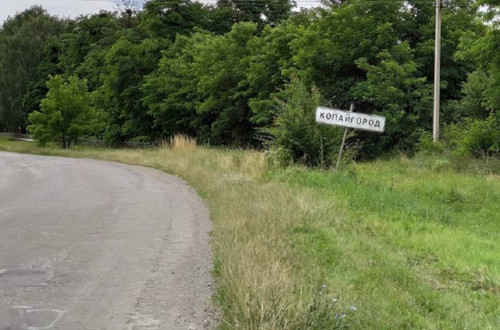
Ulaniv, Zhmerinka, Bar, Murovani Kurylivtsi, Kopaigorod, Sataniv and many other shtetls in Podillia were all similar. But I will write about the most typical one which was where my parents lived. My family moved to the village of Kopagorod in January 1955. After the death of my grandmother, her sister, Ester Hershkovich lived in a house in the town. During this time period my father was transferred to Kopaigorod to work in the communications office in the post office as the chief accountant. I had already finished the first grade and my sister, Galya, had finished second grade.
Kopaigorod greeted me with January frosts. I immediately made many friends here, and as they say, I plunged headlong into Jewish life. My memories are confused. Some memories disappeared, some seem to be absent, and some have come to the fore. In the town they said: “What was happening is better than what will be happening, just because it was.” For me, Kopaigorod, where I grew up, is the best place in all of Vinnytsia. Everyone here understood that our streets were not the central highways of the Earth, but they were still our paths and our land.
|
|
Back in ancient times, four to three thousand BC, there was an ancient Trypil settlement on the territory of Kopaigorod.
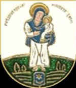
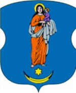
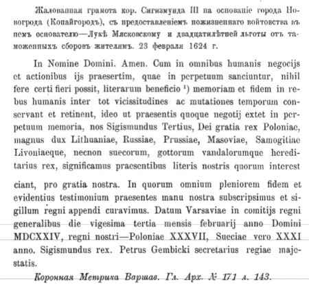
Kopaigorod had an historical coat of arms, approved on February 23, 1624. The Mother of God holds the Savior in her hands on a silver shield and below her is an azure shield with the coat of arms of the founder of the city. It depicts the moon with its horns up and a six-pointed star, above the inscription “Patrona oppidi Novogrodensis” (Patroness of the city of Novogrodsk). The shield is framed by an azure ribbon from below. The crescent and star were taken from the family coat of arms of the owners of Kopaigorod: Myastkovsky. Why was the Mother of God chosen as the protector of the city? Apparently, its inhabitants believed that it would preserve the town built on the Kuchmansky Way, {a trade route between the Dniester and Southern Bug rivers between Crimea and Poland} protect its inhabitants from troubles and enemies, and help them survive in bad times. And this influenced the choice of the king.
The noble coat of arms of Leliva (Leliwa in Polish) is first mentioned in documents from 1324. After the Union of Horodel in 1413, many coats of arms, including Leliwa, were officially assigned to representatives of the Lithuanian-Russian (Ukrainian) nobility, and the rights of the Catholic nobility of the Kingdom of Poland, and the nobility of the Grand Duchy of Lithuania, Russia, and Zemantia were equalized. According to the terms of the union, this coat of arms was handed over to the family of the elder of Vilno Moniwid by Polish noblemen Jan Tarnowski and Jadwiga from Lezheniec. Later, the coat of arms was used by 830 families from Belarus, Lithuania, Poland, and Ukraine, including the Abramovichi, Hlebovichi, Dobryanskyi, Dorogostaiskyi, Yelze, Zaberezinskyi, Zaglinskyi, Manivedovychii, Myastkovskyi, Olekhnovychii, Pyletskyi, Seniavskyi, Tarnovskyi, Tyshkevichi, and Chapskyi. In Ukraine, the coat of arms acted as a basis or as an element of the coats of arms of the cities of Ternopil (coat of arms of the Tarnovskys), Kopaigorod (coat of arms of the Myastkovskys), Granov, Zavalov, Mykolaiv in Podil (coat of arms of the Sinyavskys).
The coat of arms had a golden crescent with its horns up in a blue field, above which is a golden six-pointed star.
|
|
|
|
|
|
|
|
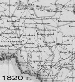
According to the administrative division, the town in the 17th century was a part of the Letychiv povit. In the 18th century it was part of Kopaigorod povit, and in the 19th century it was in Mogilev povit. According to the resolution of the Ukrainian Executive Committee,VUCVK, of July 6, 1921, the Zhmerynka povit was created on the territory of Podillia gubernia, which included 12 volosts or regions, including Kopaigorod. According to the administrative division, from March 23, 1923 to September 10, 1959, the Kopaigorod district still existed. According to the population census in 1926, there were 31,298 people residing in the Kopaigorod district. The percentage of the population was as follows: Ukrainians – 87, Jews – 9.5, Poles – 3, Russians – 0.2. From May 4, 1935, Kopaigorod was a part of the border zone of the Mohyliv-Podilskyi border district.
|
|
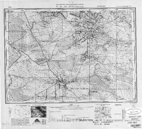
of the General Staff of the Russian Soviet Federative Socialist Republic, RSFSR |
Kopaigorod became an urban-type settlement after 1956. It was part of the Bar district of the Vinnytsia region from September 1959 through 2020. According to the new territorial distribution, it is a part of Zhmerynka District of the Kopaigorod Settlement United Territorial Community.
|
|
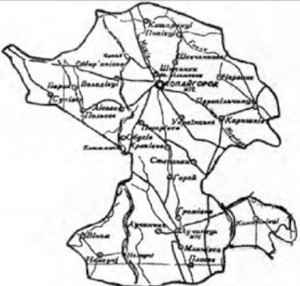
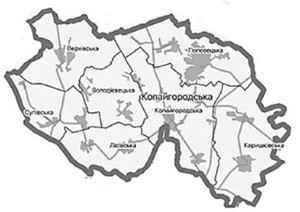
The community includes the following village councils: Verkhivka, Volodivietka, Karyshkivka, Lisivka, Popovets, Supivsk and Kopaigorod. In total, there are twenty-one settlements with the administrative center in Kopaigorod. The total area of the community is 306.9 km². The population as of 2021 was 8,130. The Kopaigorod territorial community is located 347 km from Kyiv, 85 km from the regional center of Vinnytsia, and 51 km from the border with the Republic of Moldova. It borders Barsk, Murovani Kurylivtsi, Shargorod and Stanislavchyk communities of Vinnytsia region. The Cabinet of Ministers of Ukraine by Resolution No. 878 of July 26, 2001 approved the List of Historical Settlements of Ukraine, which includes Kopaigorod settlement.
|
|
The village is located on the Nemia River (a tributary of the Dniester) in the western part of Vinnytsia, 70 km from the regional center, 27 km south of the former district center of Bar and 5 km from the Kopay railway station. The area is 3 square km. The population was 1,493 in 2001, which is 77.5% compared to 1989. The Nemia River originates near the village Mytky, flows through Bar, Murovani Kurylivtsi and Mohyliv-Podilskyi districts. The length of the river is 64 km. Kopaigorod is located in the hills.
The owner of the town was L. Myastkovskyi. His heirs had control of Kopaigorod for about 40 years. After the death of L. Myastkowski in 1654, his son Wojciech became a tenant of both Kopaigorod and the surrounding villages of Onushkivtsi (now called Novi Galchentsi), Shipynka, Murovani Kurylivtsi. At the Diet of 1672, King Mihai confirmed the lease of Kopaigorod to Wojciech. Wojciech Myastkowski (previously mentioned concerning the coat of arms of Leliva), was first a royal nobleman (as early as 1607), then a kamianets (a person that served a duke or a king) from 1621-1637, then the sub-chamberlain of Lviv from 1637 to 1653. He became the Kopaigorod chieftain in 1637 and died in 1654. Kopaigorod was deserted during the Turkish raids. The widow of Wojciech, Agnieszka, began to manage the town in 1700. History indicates that the Rostkovskys ruled Kopaigorod from 1765, and after 1775 the Vyslovskys were in charge. In 1776, Mateusz Sulyatskyi, the treasurer of Ovrutskyi (of the Sas family) owned the Kopaigorod povit. From 1790, the town was owned by Józef Sulyatskyi, the chamberlain of the Polish court, son of Mateusz. Subsequently, Maryan Sulyatskyi, son of Joseph, managed it. Maryan lived a long life but had no heirs. Before his death in 1885 he bequeathed his estate to the Kopaigorod peasant, Matryona Skorobagach-Bogutskaya.
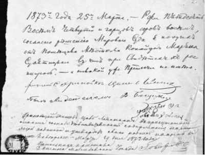
A number of documents from the fund of the landowner Sulyatskyi's family follows.
|
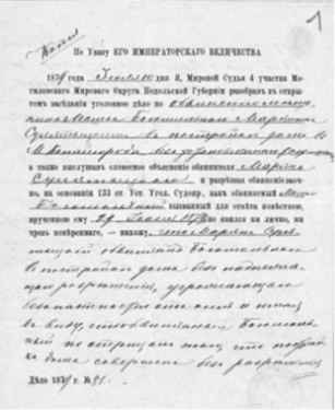
This document states that according to the decision of the Magistrate's Court on March 25, 1873, the Khrenivets resident Tsalo Levinson received a debt of fifty-eight quarters and forty-eight quarters of rye from the landowner of the Kopaigorod resident, Maryan Sulyatskyi. V. Sulyatskyi acted as a witness and was approved by the assistant bailiff of the 3rd district of the Mogilev Congress of Magistrates' Courts.
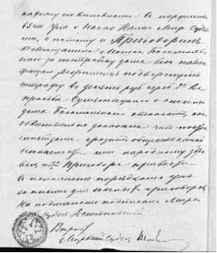
There is more information about Sulyatsky's life. The house of Moshev Bogomolny, a resident of Kopaigorod, burned down in 1874. He built a new one in the same place without permission, two and a half arshins (about 180 cm) away from the estate of the landowner Maryan Sulyatskyi, who was dissatisfied with this and filed a petition in court. This case had been under consideration in different instances for a long time. In 1879, the justice of the peace of the 4th precinct of the Mogilev-Podilskyi peace district ruled that M. Bogomolny was fined 10 rubles in silver for building a house without a permit, and he was now obliged to obtain all the necessary documents for the house. The request of M. Sulyatsky regarding the demolition of the Bogomolnyi house was refused. This happened, but rarely. In the period 1672–1699, the town fell within the boundaries of the Ottoman Empire. After the second partition of Poland, in 1793, Kopaigorod came under the rule of the Russian Empire.
|
|
Taking into account the historical logic and the needs of that era, in 1624, the Polish king Sigismund III ordered Luka Myastkovsky, “the ruler of the crown estates of the chieftainship of Bar”, to choose a convenient place between the villages of Romanka (now Ukrainian) and Shepyakiv (now Shipynky) and to establish fortifications there. This place became the city of Novogrod, a part of the Galchynets estate, which Myastkovsky managed to control in 1622–1629. Construction took place on the triangle between the Nemia River, its tributary Mala Nemia and a deep ravine. And so, the triangle was washed by water on two sides, a deep ditch was dug on the third side, and an earthen rampart was poured over it, which was strengthened by an oak palisade.
By a deed dated February 23, 1624, the king approved Myastkovsky as a voivode, (or governor) of this administrative area, in Novogrod. This included the right to consider court cases of a civil and criminal nature (together with six advisers and six jurors) and ordered the town to be fortified with ramparts and ditches.
|
|
Myastkovsky approved auctions on Fridays and Sundays and four fairs a year. Fairs were held on the first Sunday after Easter, on St. Basil's Day, and on the Thursdays after the holidays. He granted the inhabitants protection under the Magdeburg law and also freed them from paying various taxes for twenty years. According to historical documents, the bazaar was located in the place where the post office is now; the central location made it a good site for fairs and trades. This had a great impact on the locals; the Kopaigorod dialect can still be heard in business related expressions. Trade was carried out from sleds during the winter; there was even a separate road so that livestock would not be driven through the center of the bazaar. Auctions took place in the old post office location in the Jewish quarter. Kopaigorod was generally the trade center of the district.
But how could the new town, which was supposed to be a kind of stopover for merchants and traders, their protector and fortress, succeed? In his collection of historical essays, Bar's Old Age, M. Hrushevskyi wrote:
These town foundations, however insignificant they may be at times, are nevertheless recognized to a certain extent as proof of the density of the population, the need for trade and industrial centers. These same towns, mainly southern ones, such as Shargorod, Kopaigorod, Dombrovtsa, Verbovets, also had other meanings - fortified points, castles that protected the population from the Tatar roads, as it was inseparably connected with the concept of a city in Ukraine.
In 1629, there were already 50 houses in the town. At the end of the 17th and the beginning of the 18th centuries, the owner of the town was Oleksandr Jan Yablonovskyi. In 1635, Kopaigorod separated from Bar povit. Later, the Kopaigorod povit was created, which included the surrounding villages. According to the lustration of 1765, the town was the center of a separate povit, which included Kopaigorod and Murovani Kurylivtsi. Antonio-Ignatsi Mankivskyi-Zaremba already owned the town (1740–1810). He sold Kopaigorod and the village of Romanky to his brother-in-law M. Sulyatskyi. In 1793, the town became the property of the Sulyatsky family. In the 19th century it was the Kopaigorod parish with its center in the village, Karyshkiv, and from 1890 Kopaigorod became the center of the parish. The volost included the following villages, listed here with their 1913 names: Berlintsi Lisovi - 295 yards, Berlyadka - 117 yards, Galchyntsi - 172 yards, Grabovtsi - 259 yards, Dolgivtsi - 418 yards, Katsmazov - 658 yards, the town of Kopai-Gorod - 218 yards (only rural population), Karyshkiv – 373 yards, Obukhiv, Perepilchintsi, Romanky, Stepanky, Khrynovka.
King Sigismund III approved a seal for the town with the image of the Mother of God, under whose feet there is the coat of arms of the “builder Leliva” (a hexagonal star with a crescent moon - many nobles had such a coat of arms) and the motto PATRONA OPPIDI NOVOGRODENSIS, meaning patroness of the city of Novogrod.
L. Myastkovsky gathered people to work on the mound of shafts around the future Novogrod. The diggers were so fed up with this urgent digging and piling of shafts that they nicknamed this new building “dig-horod”. A little later, the French engineer Guillaume Levasseur de Beauplan built a regular fortress and a whole network of underground passages, but the name Novogrod did not stick. He mentions the town in the book, Description of Ukraine, written in 1650. Novogrod was built as a medieval town with a fair square and shops, which is why it became the craft and trade center of Eastern Podillia. Everyone called it the town of Kopaigorod. Kopaigorod is mentioned in the royal orders of 1635. Therefore, we can say with confidence that the name of the village comes from the words “to dig ramparts and fence”. {Kopay in Ukrainian means to dig.}
In his report on the settlement of the Podil Voivodeship for the early 17th century, Mykola Krykun wrote that the town on the royal lands of Galchyntsy was probably first called Novy Galchyntsy, and later called Derigorod, Novogrod, and then Kopaigorod, and the final name stuck. (Records of the Shevchenko Scientific Society No. 243 dated 01.01.2002, p. 409)
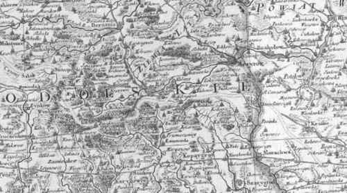
The area on which Kopaigorod was built is located on the Kuchmansky route, which runs through Bratslav, Bar, Shargorod to Cherkasy. A fortress was built to protect against Turkish and Tatar raids on the territory of the Polish-Lithuanian Commonwealth. According to the construction plan, the fortress was an outpost. A defensive castle and watchtower were built on the high bank of the Nemia River, and auxiliary services were built on the opposite bank of the river. All this was surrounded by earth ramparts and bypass ditches. Later, all the elements of the fortress were connected by underground passages.
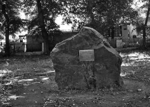
On September 12, 1999, a granite block-boulder was installed in memory of the founding of Kopaigorod. A plaque was installed on the front part of the granite with the inscription: “Memorial sign in honor of the 375th anniversary of Kopaigorod, founded by Lukasz Kazimierz Myastkovskii.”
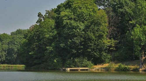
The dam blocked the Nemia River and a pond was created mainly to regulate the water level in the ditches, and a mill was built there. The river was clean at the start of the 20th century. There was a sugar factory in the village of Hrenivka (now the village of Privitne) that was owned by the landowner General Ustinov. Unfortunately, wastewater from the sugar plant was discharged into the river. Due to this, all of the fish disappeared. People didn't worry about disappearing fish on the lord's property, but they did worry about the terrible stench in the area that made it hard to cross the river. Typhus broke out in the area and pigs died. There was no place for farmers to water their cattle and wash their clothes. (Rada newspaper for 1907).
|
|
Photographer: Evgeny Schneider, Used with permission. Source URL: https://myshtetl.org/vinnitskaja/kopaygorod.html |
|
|
Used with permission. Photographer: Irina Pustinnikova. Source URL: https://castles.com.ua/kopayhorod.html |
A park was created above the pond with avenues of yellow acacia, maples, chestnuts and fir trees. The large palace of Luka was located here, and in the 19th and early 20th centuries, a local landowner owned an estate in this location. Near the entrance to the park on the left side were the Master's graves. Further along the alley is the football field, and behind it on the hill there is an old garden. Behind the garden was an estate in which Petro Gonchar served as the landlord's manager. Kopaigorod residents dismantled the estate. The Perebudoka collective farm was located on this site.
In July 1648, the population of Kopaigorod revolted. As they received support from the troops of Maksym Krivonos, they put an end to the Polish lords. The nobleman S. Roscyshevskyi wrote a letter from Kopaigorod about the events of that period.
On June 22, the Cossacks took the Nestervar castle in which several dozen nobles were trapped. We fought back with a force of 500 soldiers. At first we were lucky. We killed more than 300 enemies in the area near Klevan, and several hundred more who broke into the city were killed there. But Kryvonis came with 4,000 men and guns and repaid us for yesterday. We lost more than 200 people. Mr. Okun, Mr. Kholdakovsky, Mr. Baibuz, and more than ten other servants of the full hetman {Polish military commander} were driven away from the castle, because the besieged rebels made a sortie and we had to retreat to Shargorod. They took the castle with the help of tricks but they didn't keep their word and many nobles were killed. We don't have the exact information yet. Many Jews were killed, the church was looted, silver was torn from the coffins of the late Vinnytsia mayor and his children. We do not know if Prince Jan Chetvertynsky, who was there with his wife, is alive. They captured all the artillery. A mass of 67 peasants joined them. The prisoners, who were brought to us yesterday, agree that the rebels should go to Shargorod, and then to Bar, and today they are already building a bridge for artillery on the Silnytsia River. If such a powerful fortress could not withstand the massacre of Tulchin or the massacre of Nestervar we had to leave Shargorod and go to Ternopil. On the way we met very suspicious villagers. There is only one Cherkasy regiment of Cossacks here, and all the others are subjects of the full hetman and the crown prince. They say that 12,000 of them rose up from our Master's estate, that several villages passed to them in a few days, and when they approached Shargorod, the mass would also join them. I give myself to it. In Kopaigorod on the day of St. Jan 1648.
In the autumn of 1653, Poland began to withdraw considerable forces to the Podillia region, and the battles near Zhvanets unfolded. The main forces of the peasant-Cossack troops led by Bohdan Khmelnystskyi were concentrated in this area. Under Hetman Pavlo Tiur, the Polish magnates re-instituted social, economic and religious oppression. In 1664–1665, the population of Kopaigorod participated in the uprising led by Colonel V. Drozdenko (Drozd).
In the fall of 1674, the Polish King, Jan Sobieski, went to the right-bank lands of Ukraine to consolidate his power. The Polish nobleman, J. Tuchinsky, a participant in the campaign, wrote interesting testimonies about Eustafiy Gogol. “Before the Cossack war, he was engaged in robbery, then he was always with the Cossacks in riots, then surrendered to the Turks when they came near Mogilev.”
When the numerous troops of the Polish-Lithuanian Commonwealth approached the walls of this city, the Ukrainian colonel captured and handed over two Tatar murzas (princes). These princes collected tribute from the city population on behalf of the sultan, for the Polish colonel M. Zhevusky. “Immediately after this, Gogol went to swear an oath to the king,” the entry in the diary testified. On October 28, 1674, Jan III Sobieski informed the chancellor of the Grand Duchy of Lithuania about the citizenship of Podilsk and Bratslav colonel Eustafiy Gogol.
The transfer of these regiments to the king's side was of great importance for strengthening the power of the Polish-Lithuanian Commonwealth in Right-Bank Ukraine. This is evidenced by the universal law of Jan III Sobieski dated November 22, 1674, which granted great freedoms and privileges to the residents of these regiments. In particular, it was noted that to Colonel Gogol “under his leadership we give the cities of Mogilev, Shargorod, Ozharyntsi, Yarokhov, Yaruga, Beluya, Mykhailovka, Busha, Rashkov, Yampol, Chernivtsi, Kamenka, Kolodets, Tsekinovka, Kuzmin, Kopaigorod, Luchynets, Murakhva, named so by all the villages and settlements that belong to them.” In addition, the Cossacks who lived in these places were freed from “all the arrogance of the lords of the tyrants… all statutes, taxes, rents, works…”. In order for the Cossacks and the colonel himself to be loyal to Polish protection, the King allowed them to be engaged in beer and vodka industries.
The burghers of Kopaigorod and the landless peasants actively participated in the Haydamak movement, which began in 1734 in Shargorod. Centuries have passed, but until now the picturesque meadow near the pond with a well in the Berlintsi tract, where Berlan and the rebels stopped to rest many times, is still called Haydamachka by local residents.
Earthen fortifications were mostly torn down over time. The town grew and kept its name as an historical curiosity. The remains of the ramparts could still be seen in 1901 on the northeastern outskirts of the town (Works of the Podolsky Eparchyal Historical and Statistical Committee, 1901, vol. 9).
The German traveler Ulrich von Werdum wrote about life in Kopaigorod and Podillia at the end of the 17th century in his diary. “Bar, Kopaigorod, Shargorod, and Luchynets used to be beautiful places, with beautiful buildings and churches, but now they are mostly completely devastated. Local craftsmen were great masters at making knives and sabers, which were famous not only in Ukraine, but also in Poland.”
The blind kobzar {flute player}and tinsmith Kupriyan, who in 1875 lived for some time in Kopaigorod, wrote about Kopaigorod in his songs and sang them to ten-year-old Mykhailik Kotsiubinsky in Bar. From folklore records:
Oh, I will go to Kopaigorod,
To Kopaigorod and to the fair.
Yes, I will buy an expensive ship,
For one hundred and twenty rubles.
Ukrainian artist A. Slastion visited a fellow student from his art academy who lived in Kopaigorod, 1876. Here he met the young priest F. Chernetsky, who played the guitar and sang Ukrainian songs, and who introduced Slastion to the song, Batko Negrebetsky. A.G. Slastion recorded historical songs and works of bandurists during his ethnographic expeditions. I. Franko wrote about this in Notes of the Scientific Society, named after T. Shevchenko v. 45. Perhaps while Slastion was in Kopaigorod, he painted pictures of views of Kopaigorod and its local residents.
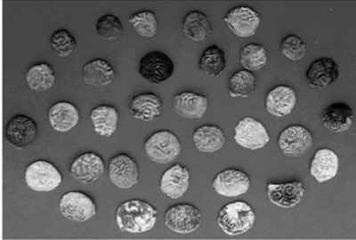
Many artifacts testify to the active trade and industrial activity in the town. R. Gulya, a town resident, found a treasure of coins while digging in a garden in April 2005. The Kopaigorod treasure contained 59 silver coins of the Commonwealth of Nations. The oldest coin found in this treasure is from 1665 under the rule of Jan II Casimir (1648–1668). The most recent is a three kopeck coin, dated 1755, from the rule of Augustus III (1733–1763). Perhaps the owner intended to hide the treasure in the ground for a short time as no other artifacts were found in the same area. Unfortunately the Kopaigorod treasure was taken to Russia and the opportunity to study it in detail was lost. In 2011, a treasure that included silver coins from the Crimean Khanate of the 15th -16th centuries, was found beyond Kopaigorod in the direction of Ukrainskyi. These silver coins were from the Crimean Khanate of the 15th- 16th centuries.
The Bar treasures of 1891, 1978, 2002, Yaltushkiv - 1897, Volodiiv - 1857, Zhuravliv - 1990, and Kopaigorod - 2005 and 2011 allow researchers to conjecture that among the circulation of money of the Kopaigorod and Bar povits in the 17th - 18th centuries, Polish, Lithuanian, Prussian, Swedish, German and Hungarian coins prevailed. There were 2,067 silver coins from different countries found among these six treasures.
|
|
Recent landslides that occurred in the town opened some of the underground passages from the past. It was dangerous to enter these passages as they were simply covered with earth. These were underground hiding passages, where the population hid during the long-term defense of the town. No studies were ever conducted to examine the underground passages. When I was a student in the 1950's we heard stories and legends about mazes and dungeons in the area. Everyone claimed that if the Americans attacked there would be no way to escape as no one had actually ever seen the basement rooms hidden under the earth.
There were once Turks in this area and they were digging underground passages near Kopaigorod. They dug all over. We would build a store here or there, and suddenly a hole appeared and the store would collapse. Everyone had their own basements, and there were cases when a huge hole suddenly formed in the center. It was scary. It's even scary to walk in Kopaigorod because of these Turkish underground passages (from the story of D.I. Yatskova-Kreimer, born in 1924, Kopaigorod, 2001, recorded by O.V. Belov, A.V. Sokolov, V. Ya. Petrukhin). blockquote>After the partition of Poland and the accession of Podillia to the Russian Empire, Kopaigorod became part of the Mogilev district of the Podillia province. Subsequently, the Podilsk governor, M. Verderevskyi, decided in April 1796, to transfer Kopaigorod to the Bratslav province, but after some time the town again became part of the Podillia province. This transition took place at the request of Field Marshal Count Peter Rumyantsev-Zadunayskyi as “the settlements granted to him should be dependent on the same province.” On April 8, 1796, Governor-General Tutolmin sent his proposal from Vinnytsia to Podillia Governor Mykola Verderevskii. He requested:
By mutual agreement with the Bratslav lord governor, to order the villages of the landowner Borzheyskyi, the village of Mateykiv, the sloboda of Mateykivska, the landowner Galchynskyi, located in the Verbovetsky District the village of Galchyntsi and the landowner, the town of Sulyatskyi, the town of Kopaigorod and the village of Romanky, in which, according to the initial description, 1,333 souls of male settlers are shown, to be transferred to the department of police officials of Mogilev district as those joining the Bratslav province. Instead separated from the local (i.e. Bratslav governorship) ) most graciously granted to his lordship Count Pyotr Oleksandrovych Rumyantsev-Zadunaiskyi, the villages of Serebrynets, Ilyashivtsi, and the property of the landowner of Sulyatskyi village, Yurkivtsi and Izraeliovka, in which there are 1,399 souls, order to be accepted into the department of Verbovetsk district.
The town's population of Poles, Jews and various merchants grew rapidly. In 1888, there were 1,516 inhabitants in Kopaigorod, of which 789 were Jews. There were 282 households, one church, one cathedral, one chapel, one synagogue, and two Jewish prayer houses. There was a distillery, a water mill, 55 shops, 30 artisans, 26 market days a year, a pharmacy, and a parish council. Kopaigorod experienced different times of prosperity and devastation, joy and sorrow. According to the population census in 1939, only 2,876 people lived in the town, including 1,754 Ukrainians, 1,075 Jews, 25 Russians, 20 Poles, 2 others. In 1959, while still a district center, there were 4,945 people. In 1970 there was a smaller population of 1,958, and in 1989, the population stood at 1,927. Until 1917 there were about 4,000 people in Kopaigorod, half of whom were Jews. Jews settled compactly in the center of the village. From here, the center had a kind of characteristic building containing houses with galleries close to the street, under wide red tiled roofs worn out by time, with plastered and whitewashed walls that sparkled with blue.
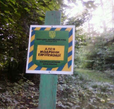
An interesting point of the village is Vodogray, a hydrological reservation of local importance located on a pond in the bed of the Nemia River on the eastern outskirts of Kopaigorod. This territory was declared a reserve in accordance with the decision of the 16th session of the Vinnytsia Regional Council of the 6th convocation of 20.06.2013, No. 548. The territory is a body of water in which wetland vegetation such as common reed, broad-leaved sedge and arrowroot grow. Black alder and marsh puddle grow on the banks. There is a forest reserve in this area, called Larch Reserve, where tourists are attracted by an avenue of European larch planted in 1900. This miracle of nature is located in the village Kopaigorod in the direction of the village Mateykovo A two-lane avenue of spruce and larch is 3.2 km long.
According to the new administrative-territorial division of Ukraine in February 1932, the Kopaigorod district with its center in the town of Kopaigorod, had an area of 767.1 square km. that included thirty-seven village councils.
There is a street called Kopaigorodska Street in the capital of Ukraine. It is located in the Podillia district of Kyiv, in the area of Belyche Pole. It runs from Bilytska to Polkova Street. It arose in the first half of the 20th century under the name 89-a Nova. Since 1944, it has been called Khmilna. The modern name is from 1952, in honor of the village of Kopaigorod. (Decision of the Executive Committee of the Kyiv City Council of Workers' Deputies On Changing Street Names, dated 03.01.52, No. 5). Not every village can boast of such a fact.
|
|
|
|
JewishGen, Inc. makes no representations regarding the accuracy of
the translation. The reader may wish to refer to the original material
for verification.
JewishGen is not responsible for inaccuracies or omissions in the original work and cannot rewrite or edit the text to correct inaccuracies and/or omissions.
Our mission is to produce a translation of the original work and we cannot verify the accuracy of statements or alter facts cited.
 Kopaihorod, Ukraine
 Yizkor Book Project
 JewishGen Home Page
Copyright © 1999-2026 by JewishGen, Inc.
Updated 22 Jul 2025 by LA