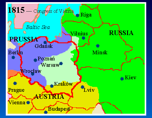
12. Map 1815 - Congress of Vienna
 |
|
|
|
|
Map Key: Red Lines = Modern borders Green = Russia Light Green = Kingdom of Poland Blue = Prussia Gold = Austria Tan = Ottoman |
In 1815, Napoleon was defeated at Waterloo, and the conquering powers met at the "Congress of Vienna" to divide Napoleon's spoils. The "Duchy of Warsaw" was split up: the Grand Duchy of Posen was returned to Prussia; Kraków became a Free City (until 1846), under the auspices of Austria; and the largest part was ceded to Russia, and became the "Kingdom of Poland" (shown here in light green), which was a Kingdom in name only -- the King was the Czar of Russia.
Thus the borders of Europe were set for next 100 years, until World War I. This was the map of Europe during the era when many of our ancestors left Poland.
What is Poland today (thick red line) was divided between