 |
|
|
[Page 10]
by Menachem Katz
[Same as English version]
One day somebody will ask you: Who are you? Where did you come from? Who were your ancestors? What was their nature? What did they do? In other words, if you want to learn about your family's past, just read the book. You would find another world, different from your world but close to your heart.
This book was written by people who devoted a substantial effort to collecting the material and brought it before the reader without adding or deducting anything.
We like to take the reader on a small tour of the city's streets and show him the “Kheder” where we studied. Our kindergarten and elementary school. We want to show the reader the big synagogue during the “Days of Awe,” the home of a religious Jew on Friday night when they blessed over Shabbat candles and welcomed Shabbat with the words “Shalom Aleichem” [“Peace onto you”]…
We intend to show the community's leaders and the people's poor. To listen to a debate between Torah learners and the ordinary daily talk of the people. We will pass through the market and meet the merchants and their helpers, peddlers, porters, wagon owners, and artisans busy with their hard work. We would like you to see their life from different sides – in joy and, G-d forbid, in sorrow, on regular days and holidays, summer and winter. Only that you will be able to understand the secret of your past. You will learn where you suckled your wisdom and courage. You will know that you have not come from an empty space, that there is a tied connection between you and your past, and that there is no shame in that past. It was an arduous past, sometimes tragic. But your ancestors withstood that past honorably, and despite all the difficulties and the grueling struggle – they never surrendered!
Everything we have accomplished was thanks to their deeds, stubbornness, wisdom, and tradition. Your ancestors kept two basic commandments - at all times and under all conditions: “love of Israel” and “mutual aid” and therefore managed to maintain the religion and the unity of the people.
[Page 12]
|
by Dr. Eliezer Shaklai[1]
Translated by Moshe Kutten
Edited by Jane S. Gabin
It's worthwhile to describe, in a few words, the city itself, which would make the understanding of the topic in question and the happening at a location and time.
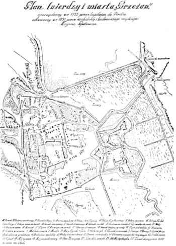
The small town of Brzezany is situated in southeast Galicia, about 100 kilometers from the city of Lviv, in the triangle between the cities of Lviv, Stanislovov, and Tarnopol, hidden between trees and forests, close to the river Zlota–Lypa, at the edge of a lake in a low valley.
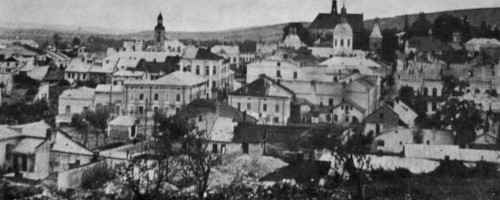
Seemingly, the town was like all other towns in that area, yet, there was something unique about it that distinguished it from the rest: an incredible beauty and outstanding cleanliness. Brzezany was small in terms of its area or the number of its residents. Despite being small, the city was known in the world due to the Torah's great scholars and Poskim [deciders], who acquired a name for themselves beyond the limit of our town.
|
[Page 15]
The Area Around the City
|
|
The lake lies on the city's northern side. Two huge forests - Zbiyezhinetz and Roriska - lie on two sides of the city, the southeastern side and the southwestern, both reaching the Carpathian Mountains.
Many types of trees grow in these forests: conifers such as pines, oaks, and cypresses, and also fruit trees like cherry, walnut, and apple. Among the trees, meadows cover the ground like a multicolor carpet, seeded with many flowers and fruit bushes including strawberry and raspberry.
Fields of grains and vegetable gardens spread around the city like a beautiful picture frame; the city's surrounding provides fruit and wood for heating and wood-based industries. There was fresh air, and a pleasant place to spend time.
Four roads, running in four different directions from the center, connect it with the rest of the world; there is also another connection, on the east side of the city's center. Brzezany boasts of -– the railway, passing in south-northern directions; the train station is about a kilometer from the city's center.
Thus, Brzezany is the central town of an entire region. Several villages with a population of one hundred thousand citizens are under its authority. Brzezany is a provincial city; several villages and towns (such as Kozowa and Narajow) with a population of one hundred thousand are under its authority. These residents are tied to Brzezany municipally, economically, and culturally.
The city itself is divided into five sections: the center, and four suburbs, which spread along the four main roads. In the north: Siolko; in the east: Khatky; to the south: Adamowka; and to the west: Miastczka.
A Look at the City
You can get an overall view of the city if you make the effort and climb to the highest point, in the northwestern corner of the city: Bernardines Mountain. On the top of the mountain stands the Bernardines' Monastery, a beautiful ancient building, big and long, with a bell tower. The monastery dominates the entire city, and the viewer is rewarded with an unforgettable view of the city. I loved the sounds of the bells. In them, I heard a whole chorus. It sounded divine and alluring. I loved climbing the mountain above the monastery and looking down at the entire city from above, with its streets, alleys, beautiful houses, flower gardens, and fruit trees. I could see the beautiful view, space toward infinity.
Usually, there were only just a few monks at the monastery. The place was quiet throughout most of the year. Only once each year, in the summer months on the holiday of “Holy Antony,” the day of atonement in that monastery, tens of thousands of Christians came from near and faraway places to pray here for atonement for their sins.
The festivity began on the evening before the day of atonement. People gathered around the monastery, lit fires, sang, and danced throughout the night. It was a day that was all good. The Gentiles prayed for atonement for their sins – it was a market day for the Jews. It provided subsistence for several weeks. It was also a fun day for us, the children. The streets filled with people and merchants' stalls. People came from far away, whom we did not see throughout the year, with their goods: clothing, food, and even children's toys. We kept away from the Kheder and ran around in the streets until late hours.
[Page 16]
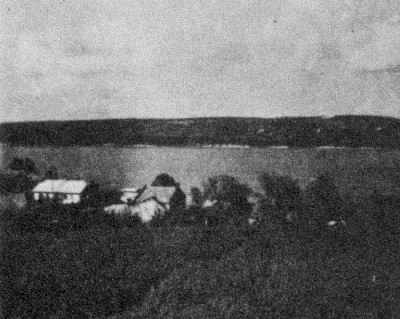
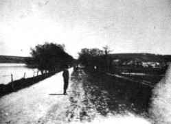
From the top of the mountain, one can see, stretching like a mirror, the long, broad, and magnificent lake framed east and west by mountains and hills. Two roads run along the length of the lake: on the east – the railroad, and on the west – the road leading to Lviv.
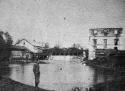
Serving as a source of sustenance and relaxation, the lake is an essential resource for the residents. The lake provided fish during all months of the year. In the winter, people harvested ice blocks and preserved them for the summer months. A five-story flour mill took advantage of the difference in the water level between the lake and the valley below. The mill was destroyed during the First World War and was never rebuilt. For us, the youngsters, the lake served as a pleasant place for recreation. In the summer, we used to bathe in the lake and relax on its beach sands; in the winter, the lake served as a place for ice skating, and we spent long hours dancing on our skates there.
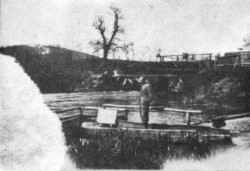
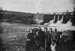
A high dam, one kilometer long and 20 meters wide, prevents the lake from shedding its waters into the town and flooding it. The water level was about 30 meters [100 meters in the English section] above the level of the market square. In some cases, most of which were in the spring, the lake overflowed its banks and endangered the city and its residents. I still recall the year 1912, toward the Passover holiday, when the lake water rose, and a substantial part of the city was covered by water. All the residents were ready to evacuate the city. During the summer days, the dam served as a place for social gatherings and a boardwalk for the youths.
The waters of Zlota Lypa River flow through the lake from north to south and leave the southern side of the lake as waterfalls, where they split into two branches, passing the city and recombining at the city exit.
East of the town, between the two forks of the river, stands a large stone structure, a remnant from the 16th century. It is a large building built from stones. A few Jewish families resided in it until the First World War. The fort also served as an elementary school for boys. A “Capela” – a small prayer house - stood in the fort's yard. A sign with the Tetragram was written in golden letters above the entrance. The Capela contained sarcophaguses with gravestones. Originally the building served as a citadel of the Siekierski[?]family, the founders of the town. In this antiquated stronghold lived and were buried numerous generations of the Sieniawski family. The citadel, together with an immense fortune, was handed down from generation to generation. The last member of this renowned family was the famous Graf Pototski, whose palace was in a nearby village Rai.
A municipal park was located on the western side of the fort. The park was big, well-maintained, and clean; now, it looks neglected. West of the park, the big and beautiful building of the Polish community center “Sokol” can be seen. Behind it, northward, stands a large but neglected building called “Reitschule.” Close to this forsaken building is a wide-open field, which belonged to the fire brigade.
|
|
|
|||||
[Page 17]
From the city's center, we shift our gaze westward. This area is the most beautiful part of the city; glorious buildings, such as the district building (Starosetvo), and the buildings of the Savings and Loans Bank, post office, court and jail, the nearby municipal hospital, new high school, and others are located there. Villas with flower gardens and ornamental trees around them are there, too. Rayivska Street, leading to the neighboring village Rai and Graf Pototski's palace, winds there in the southwestern direction, amongst the gardens and the houses. Two cemeteries lie on the two sides of the road – the Jewish cemetery on the right side and the Christian on the left. Tall trees, hundreds of years old, grow along the entire length on both sides of the road, which served as a boardwalk for young couples.
The city center (and its surrounding) was the Jewish quarter - the center of Jewish life in our city. This was where the Jews lived and where their stores, houses of prayer, and community center were. The intensive life of the city's Jews concentrated there. It is, therefore, worthwhile to go into detail about the structure of that area.
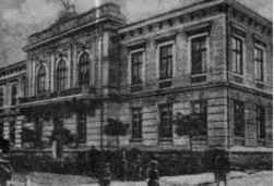
The center of the town ran symmetrically. The streets stretch from east to west and from north to south. The central building in this area is the “Town Hall” (although the municipality's offices are not located in it). It is a big square building, surrounded by a spacious yard. It is a two-story building with a tall tower housing a four-faced clock that can be seen from four directions. The clock always shows the exact time. The tower also bore the crest of Graf Pototski – a five-angled cross, three branches on one side of the center and two on the other According to legends, old Graf Pototski had six sons. This was symbolized in the original six-angled cross. However, after one of the sons converted to Judaism, the cross was flanked by only five branches.
The municipal building had two wide gates – one on the eastern side and the other on the western side. Many shops, most of which belonged to Jewish shopkeepers, were in the courtyard and surrounded the building and the square. The second floor of the building served as a high school. That school was transferred to our city from Zbarazh in 1805. Hundreds of students studied and graduated from the school, among them a substantial percentage of Jewish students. Two connected three-story houses are positioned around the central building, creating a frame-like structure.
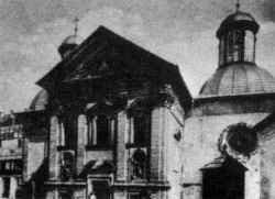
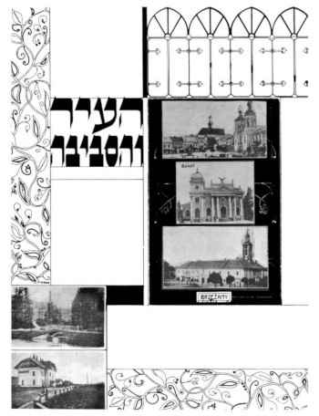
A spacious square with a bell tower is situated between the building and the surrounding houses. Roads passing in the center of the square cut it into two parts. Around the square were the churches: the Greek-Catholic, behind it the Armenian, and south of them the Catholic. All of the churches are surrounded by associated buildings, and they are connected and support each other. The Greek-Catholic church is located between the houses. On two sides, north and east, were platforms that served as parking spaces for the horses and wagons belonging to the farmers. Part of this plot was set for the local drivers and porters. All the houses in the center of the town contained stores or bar rooms owned chiefly by Jews.
In the west stood the Greek Catholic Church with three tall towers. A well and a statute of the “Holy Mother” were situated in the front square of the church. A small garden on the south side of the church contained a small statue of the Polish king, Jan Sobieski.
Stalls and parking lots for the farmers' wagons and horses were located on the northern and eastern sides and close to the building. The farmers came to the city to do their shopping and other errands. Part of the parking lots
|
|
|
|||||
[Page 18]
was slated for the local wagoneers and porters (most of whom were Jewish). Shops or taverns owned by Jews were located in the houses in the center.
Another market, the “Nowy Rynek” (the new market), was located further north between the center and the lake. That market was smaller than the central market, less appealing, and neglected. Zbozuva Street connected the two markets. The Jewish community house was located on the east side of that street. It was built after the First World War thanks to Dr. Felk's (a physician) tenacity. It was a large and stable two-story building containing a large event hall and a few additional rooms. Two oak-wood gates were located on the side of the road, with a Star of David carved into the wood.
Around the commerce center, streets and allies lined with small and dilapidated houses stretched northward, eastward, and southward. That is where the poor people lived. The Great Synagogue stood on the southern side of that quarter – a grand renovated building from the last years of the past century. Two Batei Midrash and a few small Hassidic houses of prayers were located on the way to the Great Synagogue. The Jewish-municipal ritual bathhouse, not-so-big hospital, and several other community-owned buildings were nearby.
Architect Menachem Katz describes the Great Synagogue and the rest of the houses of prayer in another chapter of this book.
[Page 19]
|
|
Translator's note:
|
|
JewishGen, Inc. makes no representations regarding the accuracy of
the translation. The reader may wish to refer to the original material
for verification.
JewishGen is not responsible for inaccuracies or omissions in the original work and cannot rewrite or edit the text to correct inaccuracies and/or omissions.
Our mission is to produce a translation of the original work and we cannot verify the accuracy of statements or alter facts cited.
 Berezhany, Ukraine
 Yizkor Book Project
 JewishGen Home Page
Copyright © 1999-2026 by JewishGen, Inc.
Updated 16 Jun 2013 by JH