|
K-R SIG HomePage Town List District Map History |
A version of this article originally appeared in the Kielce-Radom SIG Journal, Volume I, Number 1 (Winter 1997), pages 3-8.
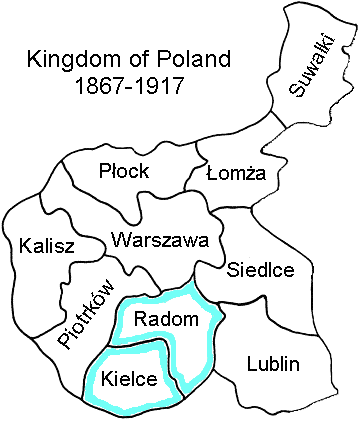
Kielce and Radom gubernias were two of the ten gubernias (provinces) of the Kingdom of Poland (Russian Poland) from 1867 to 1917. It is the area between the Pilica and Wisła [Vistula] rivers. Today, this region corresponds roughly to south-central Poland, much of the area between Warsaw and Kraków.
This area has been in many different political jurisdictions over time. For the purposes of this Special Interest Group (SIG), we define "Kielce and Radom gubernias" using the borders that were in place from 1867 to 1917, since that is the period during which the majority of our ancestors emigrated from the region.
During the 1867-1917 period, Kielce and Radom gubernias were bordered on the north, east, and west by other gubernias of the Kingdom of Poland:
The gubernias were each divided into districts (Polish powiat, Russian uezd). Kielce and Radom gubernias each contained seven districts:
Kielce gubernia:
|
Radom gubernia:
|
During the First Polish Republic (1569-1795), this area was known as Cracow and Sandomierz palatinates. Between 1772 and 1795 Poland was partitioned between the three neighboring European Empires: Russia, Prussia and Austria. In the first partition of 1772, one third of Poland's territory was taken. The area occupied by Austria was given the name of Galicia. In the second partition of 1793, Russia obtained one half on the remaining territory of Poland, while Prussia took the province of Poznan.
The third and final partition occurred in 1795, as the remnants of Poland were divided amongst Russia, Austria, and Prussia. Poland ceased to exist as a political entity. It disappeared from the map of Europe for over 100 years, not to reappear until after World War I. In the third partition, Austria annexed the large area between the Bug and Pilica rivers, including the Kielce-Radom area. Austria named this area New or West Galicia; the area that had been taken in 1772 was renamed East Galicia. West Galicia and East Galicia were merged into the single province of Galicia in 1803.
In 1807, after Napoleon defeated the Prussians, he established the Duchy of Warsaw as a French protectorate, using the territory which Prussia had taken during the partitions. In 1809, after Napoleon defeated Austria, the Schönbrunn Peace Treaty added the former Austrian West Galicia (including the Kielce-Radom area) to the Duchy. Political subdivisions were the departments of Kraków, Sandomierz, and Lublin. After Napoleon's disastrous Moscow campaign, the Duchy of Warsaw was occupied by the Russians in 1813. Napoleon's duchy lasted only six years (and the Kielce-Radom region was part of it for only four years), but it left behind a legacy of progressive social and economic reforms, including the beginning of civil registration.
After Napoleon's defeat, in 1815 the Congress of Vienna redistributed the partitioned Polish territory. Prussia received the provinces of Poznan and West Prussia in the west and north, and Austria took Galicia in the south. The city of Kraków became an independent free city. Most of the Duchy of Warsaw was given to Russia. This area was given the official name of the Kingdom of Poland (Tsarstvo Pol'skoe in Russian, Królestwo Polskie in Polish); or Congress Poland (named after the Congress of Vienna), known in Polish as Kongresówka. The area was colloquially known as "Russian Poland".
The Kingdom of Poland was established in November of 1815 as a pseudo-independent kingdom, under the rule of the Czar of Russia. The Kingdom was divided into eight provinces or voivodeships (Polish województwa): Augustów, Kalisz, Kraków, Lublin, Mazovia, Plock, Podlasia and Sandomierz. Each province was divided into districts (obwód in Polish), which were in turn divided into subdistricts (powiat). Sandomierz voivodeship was the area that would become the future Radom gubernia. Kraków voivodeship included the area that would become Kielce gubernia (it also included the Będzin area). Despite the name of this province, the city of Kraków itself was not included; Kraków was an independent city until 1846 (when it became part of Galicia).
As a result of the Polish insurrection of 1831, the territory of the Kingdom of Poland was divided in another way in 1844. Voivodeships were abolished and replaced with five gubernias (the Russian word for province): Warszawa, Augustów, Plock, Radom, and Lublin. Radom gubernia was formed from the former Sandomierz and Kraków voivodeships, and contained eight districts: Radom, Opatów, Opoczno, Sandomierz, Kielce, Miechów, Olkusz and Stopnica.
In 1867 another redistricting took place. Ten gubernias replaced the previous five: Kalisz, Kielce, Lomza, Lublin, Piotrków, Plock, Radom, Siedlce, Suwalki and Warszawa. The old Radom gubernia was split in two, forming Kielce and Radom gubernias. These borders remained in place until 1917, and it is these borders that we are using for the definition of our SIG. Outline map of Kielce and Radom gubernias, with districts, 1867-1917.
The gubernias were divided into districts (Polish powiat), which were further divided into subdistricts (Polish gmina). There were 84 districts in the ten gubernias of the Kingdom of Poland in 1867. The districts of Kielce and Radom gubernias are listed above.
Following World War I and the Treaty of
Versailles, Poland was re-established as an
independent nation after more than 100 years.
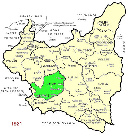
This Second Polish Republic (1918-1939)
included most of the Kingdom of Poland, plus
much additional territory.
It was divided into seventeen provinces, once again
called województwa.
The former Kielce and Radom gubernias all became
part of Kielce province.
This republic lasted little more than twenty years,
as the Nazis occupied the area.
Maps:
Polish provinces, 1919-1939:
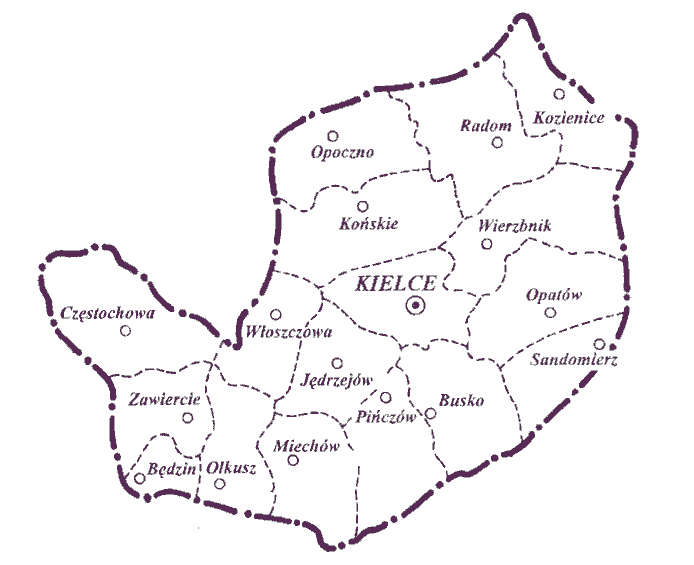
Kielce province, 1919-1939.
After World War II, the Third Polish Republic was
established, with vastly different borders —
the entire country was shifted west.
The country was subdivided into seventeen
województwa between 1945 and 1975.
The area of the former Kielce and Radom gubernias mostly
became part of Kielce province, though small parts were now
in the provinces of Kraków, Katowice, and Lublin.
Map: Polish
provinces, 1945-1975.
In 1975 Poland's internal jurisdictions were changed,
with the country divided into 49 administrative districts.
The area of the former Kielce and Radom gubernias were then
in the administrative districts of Radom, Kielce,
Piotrków Trybunalski, Częstochowa, Katowice,
Kraków and Tarnobrzeg. Most of former Kielce
gubernia became part of the new Kielce administrative
district, with the western portions in Częstochowa (former
Włoszczowa powiat), Katowice (former Olkusz powiat)
and Kraków (southern Miechów powiat).
Most of former Radom gubernia became part of the new Radom
administrative district, with parts in Kielce administrative
district (parts of former Opatów, Końskie, and
Iłża powiats), Piotrków
(western Opoczno and Końskie powiats), and
Tarnobrzeg (Opatów and Sandomierz powiats).
Maps:
Polish provinces, 1976-1998:
Kielce province, 1976-1998,
Radom province, 1976-1998.
In 1999, Poland's provinces were again changed,
with the country now divided into
16 provinces,
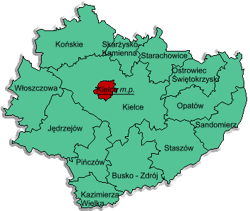
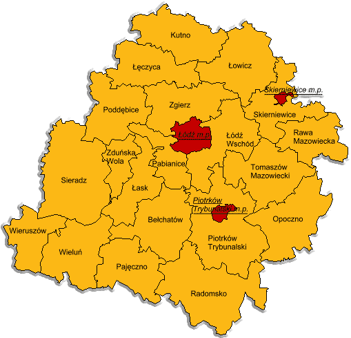
which are used today. The area of the former Kielce
and Radom gubernias are today mostly in the province of
Świętokrzyskie,
but with the northeast section
(Radom, Przysucha, Kozienice, Szydłowiec, Iłża, Zwoleń)
now in southern Mazowieckie province; the northwest section
(Opoczno, Przedbórz) now in southeastern part of Łódź
province; the southwest section (Olkusz, Miechów) now
in northern Małopolski province; and a small portion
(Pilica, Szczekociny, Żarnowiec) now in Zawiercie district
of eastern Śląsk province.
Maps:
Polish Provinces, 1999:
Świętokrzyskie,
Mazowiecki,
Łódź,
Małopolski,
Śląsk.
|
Volume 1 (1997) Volume 2 (1998) Volume 3 (1999) Volume 4 (2000) Volume 5 (2001) Volume 6 (2002) Volume 7 (2003) |
 Kielce-Radom SIG Main Page