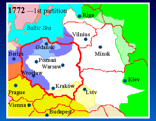
6. Map 1772 - 1st Partition
 |
|
|
|
|
Map Key: Red Lines = Modern borders White = Poland Green = Russia Blue = Prussia Gold = Austria Tan = Ottoman |
Beginning in 1772, there were three "Partitions of Poland", in which Poland's teritorry was taken by its more powerful neighbors: the Russian, Austrian, and Prussian Empires.
In the First Partition in 1772, Russia took the regions of Livonia, Vitebsk, and Mogilev (shown here in light green) from Poland. Prussia took Pomerania (light blue). Austria took Ruthenia, part of Podolia, and Kraków province (except city of Kraków), and this area (shown here in light yellow) was named "Galicia".
Prior to the first partition, there were less than 1,000 Jews in all of Russia. Via the partition of 1772, Russia acquired 60,000 Jews, Austria acquired 60,000 Jews, and Prussia acquired 10,000 Jews from the new Polish territories.