 |
|
|
[Page 53]
By Refael Moshe Sach
Translated by Chaim Meiersdorf
Representing the Majersdorf families of Pultusk
Edited by Lynn Kronzek for the Kronzek, Dronzek,
and Goldszsteyn families of Pultusk and Nasielsk
Note: Photos, maps, and illustrations with translated captions
may be viewed independently at pul682.html
Houses, Streets and Landscapes
Pultusk is located on the western shore of the Narev River, the third largest river in Poland , 52 kilometers from the capital, Warsaw. The city is surrounded by mountains on three sides. Approaching it from a distance offers a picturesque landscape of buildings lining the river and its canals; the castle tower (#27 on map) [1], built for the church hierarchy in 1522 by Bishop Rafael Leszczyński (b.1526-d.1529), juts out at river's edge.
Arriving at Pultusk from the north gives the impression of entering the gates of an ancient fortress. But to the visitor's immediately surprise is a large flour mill with many Jews working in and around it. The observer will be informed that the mill (#21 on map) was built by the brothers Israel and Zelig Rojzenberg. From the mill, a slope descends into the center of town and reveals stores belonging only to Jews. In the first shop, standing next to the anvil is the old blacksmith, with his leather apron and his hammer already in hand. Next to him is the workshop of the wheelbarrow maker, a short Jew whose tzitzit [2] reaches down to his ankles. His shirt sleeves are rolled back, and he has a grayish beard and dreamy eyes. He stands and scrapes off parts of the wheel with a wooden tool. A little further down the street, a small sign of the Jewish tailor, and opposite him the sign of the Jewish baker. And so,the length of the street,there existed just Jewish establishments until we get to the large square, where the Central Rynek (Polish for “Market”) was located (between #41and #26 on the map),filled with claves and cattle. Additionally,in the Central Market farmers and the gentry buy and sell horses or other animals through a Jewish intermediary. Further on (between #12 and #20 on the map) is the Nowy Market (Polish for “New”), where the swine market [3] was located. After the sale is completed, they enter the local pub; there a short quiet Jew with a blond beard serves them beer and roasted duck. Not far from the pub is the tea house, where the smells of animals and men mix together with the sharp odor of roasted meats. Here sit various people, and only a hint is necessary for them to understand each other. Suddenly a weary wagon driver enters and wishes to daven mincha [4] with a minyan [5]. As if by order all rise, wash their hands, and prepare for the minyan. The establishment owner, Abraham, relishes the sight of Jews who remember their creator.
As you progress around town, you will see a large building. This is the steam-producing station (#20 on the map) that was built in 1910 by Shmuel Ryng, Yitzchok Frejdlender, and Abraham Shafran and there, aside from the technician, all the employees are Jewish. Near the station are storehouses for wood and coal that have large scales for weighing tons of materials. These belong to Yehoshua Rojzenberg. All around is the noise and bustle of various vehicles, wagons, carriages, and platforms ready to transport to everywhere. On Warszawska Street is a Christian-owned sausage company that stands empty during the hot summer months.
The road is paved with smooth stones, the pavement with square bricks. All the houses are built with dried bricks, only two are made of wood. Above all, jutting out, is a building from which a tangle of wires spreads in all directions. It is the post and telegraph office (#28 on map) that connects the city with the outside world. To its right rises a wide two story building surrounded by a high fence. Above can be seen small metal grated windows. This is the well known prison of Pultusk (#39 on map); where about 200 criminals served their sentences for serious crimes. Near the prison is the “Protestant Reformed Church” (near #39 on map) that also serves the prison. On the left (going south) is Stare Miasto Street (literally “Old Place Street”), that continues to the Narev River. The street is quiet and calm, many Christians live there, but the majority are Jews. From that street one turns to Warszawska Street, and from there to May 3rd Street [6] where the two story building housing the “St. Vincent de Paul Hospital” (#49 on map) is located, established in 1594 and rebuilt in 1876. Aside from the doctors, the entire staff was composed of nuns. In times of crises and with a lot of intermediary help, Jews also received treatment and were dealt with properly.
Across from the hospital was the local theatre, built in 1910 (#29 on map). At the square connecting Warsaw, May 3rd, and Świetojańska Streets, national holidays were celebrated. At Stare Miasto Street until the river edge, which winds its way through the town, is the well known “Victoria” Hotel, where the area's landowners, famous people, and government officials would stay. At the hotel's coffee shops and restaurants, business discussions would take place between the landowners and Jewish merchants.
[Page 54]
Near Świetojańska and Przechodnia Streets flowed a small tributary that drew from the Narev, reaching the grazing fields near Rybitew and back to the Narev, such that the north and center of the city were situated as if on an island. The entire area belonged to the monastery.
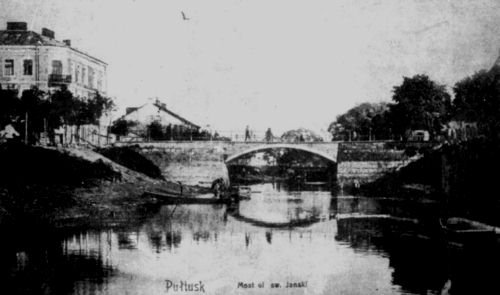
At the continuation of Świetojańska Street is a huge stone bridge, built with arches over the water. It lends a unique atmosphere to the area. People say that these bridges were built hundreds of years ago by slaves held in the monastery's basement prison. A similar bridge, called the “Cossack Bridge” was built in 1870 by a regiment of Cossack soldiers stationed in the city. The second half of Świetojańska Street crosses a boulevard where the garden of the monastery is located and there stands the 14th century castle tower (bashta, Polish), with openings for shooting.
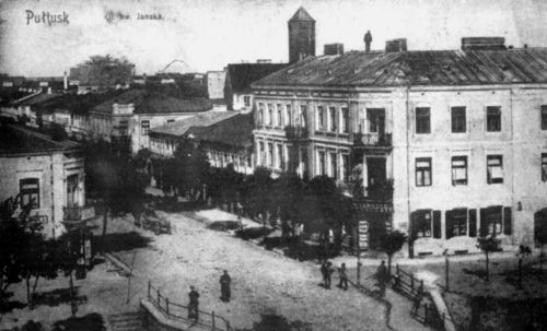
Świetojańska Street continues directly to the central market (Rynek, Polish, #6 on map), and on both sides of the street are two and three story buildings, including many shops. At the end of Świetojańska Street and far above the market was the house of Reb Gedalyahu Zylberszteyn. To the right of Świetojańska Street, at Kolarska Street (Jews called it Yatke “Butcher” Street), was the synagogue and beit midrash (study hall, #2 on map), to which the Jews rushed to daven (pray) after they crossed Świetojańska and May 3rd Streets.
The city council (#26 on map) stood to the right at the center of the market. On the top of the building was the clock, built in Swedish style. According to historical sources, it was built in 1405 by Bishop Jacob Kordovanoba, and destroyed during the battles with the Swedes. In 1728 it was restored by Bishop Zaleski, who added the tower and clock that beautifies the entire area.
Toward the right of the market, at the edge of the castle-park, is a small Christian place of worship, the very spot where, during the battles near Pultusk at the beginning of the 19th century, the foot of Napoleon's horse was broken. The Emperor came out without a wound. In the house where Napoleon lodged (No.29 on the Rynek Square), later lived Pultusk Rabbi R. Chaim Meshulam Kaufman z'l (common abbreviation for zichro l'vracha, “of blessed memory”).
Toward the rise of the mountain on the eastern side (going south) is the two story “Plock Bishop's Castle” (#27 on map), and at its feet one can see the landscape of the entire Narev River. Adjoining are small lakes, a picturesque pastoral scene with forests and farm lands. The castle with its long subterranean halls was built by the Catholic Church Authority in the 16th century and was the residence of the Bishops of Plock. Located there in a separate building was the seminary for the Catholic clergy. In addition, even the city prison and bath house belonged to the castle.
Left of the market, on the western side (going north), is the Benedictine Church (#41 on map), with a steeple, clock, and balcony. Every year special prayers were recited there, designating sunrise and sunset, the ceremony accompanied by trumpets. In the courtyard, in front of the entrance to the church, were the following verses engraved by an apostate Jew: [7]
Come and look, sisters in Jerusalem.
Oh, sisters of Zion, don't miss this!
My King-Lover
dressed and garlanded for his wedding,
his heart full, bursting with joy! [8]Truly you are a God who hides himself,
O' God and Savior of Israel. [9]
The entire church complex was established in the 16th century. On the left near Piotra Skargi, Benedyktyńska, and Staszica Streets, stands the enormous boys gymnasium (#42 on map) that was built in the classic style in 1872. While strolling on Benedyktyńska Street toward May 3rd Street, you arrive at the city park where every Sunday afternoon the army or fire brigade bands held concerts (#46 on map). Directly westward begins Kościuszki Street; opposite is the site of Pultusk's first theater, demolished when a new modern theatre was erected in 1910. The street was made up of more than 100 hundred houses, of which only four were owned by Jews and only 20 Jewish families lived there. There was also a girls' gymnasium, named after Countess Leokadia Potozka, and a finishing school. Kościuszki Street continued out of the city, passing Yankel Starosìwiecki's flour-mill. This was the way to Prussia, via the towns of Makov, Proshnitz, Chorzele, Lomza, and Augustów.
To the south at the juncture of May 3rd and Kościuszki Streets, Ciechanów Street begins. This was the location of Reb Mendel Mintz's saw mill and factory (#23 on map).
The shrill siren of the factory's chimney echoed throughout the city, announcing to the women and children that their husbands and the family's employed children were coming home from a long day of work, for a few hours of relaxation and joy. On Ciechanów Street are the big blocks of the ksarkatin (Polish for army barracks, #32 on map) that were built, or rebuilt, in the time of the Czars by Jewish contractors like Akiva Bernsztejn/Borensztejn who owned the brick factory (#22 on map), along with Gedalij Zylbersztejn who supplied the steel. The brick factory of Akiva Bernsztejn/Borensztejn was located in the northeastern section of the city, on the road towards Ciechanów and Melaba.
[Page 54]
The years have passed, an entire world was destroyed but Pultusk, the city of my youth, still stands before my eyes, with all if its love of life. I remember the main thoroughfares, the roads and little byways like Nasielsk, Telfaraptzna, Traugutta, Gorky, Zẃirki Wigury, Shvintimarie, Świetojańska, Stycznia, Zambrow, Bialowiejska, Baltazara, Rybitew, Szkolna, etc.
We lived in a Jewish atmosphere, but we were still connected to the Polish landscape, to its ends, spaces, to the rivers and forests. In this kaleidoscope of wheat and grain, rich fertile earth, windmills and factory chimneys, our town had a particular charm about it. It was considered to be unique, and one of the most beautiful places not only in the entire Mazovia District, but all of Poland.
[Page 55]
|
| Shwiyenta Yanska Street |
|
| The bridge at Shwiyenta Yanska |
|
|
JewishGen, Inc. makes no representations regarding the accuracy of
the translation. The reader may wish to refer to the original material
for verification.
JewishGen is not responsible for inaccuracies or omissions in the original work and cannot rewrite or edit the text to correct inaccuracies and/or omissions.
Our mission is to produce a translation of the original work and we cannot verify the accuracy of statements or alter facts cited.
 Pultusk, Poland
 Yizkor Book Project
 JewishGen Home Page
Copyright © 1999-2024 by JewishGen, Inc.
Updated 21 Jun 2015 by JH