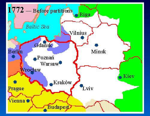
5. Map 1772 - Before Partitions
 |
|
|
|
|
Map Key: Red Lines = Modern borders White = Poland Green = Russia Blue = Prussia Gold = Austria Tan = Ottoman |
Here's the map of Poland in 1772, just before the partitions. The First Republic of Poland, a constitutional monarchy, existed from 1569 until 1795. Poland was the largest country in Europe at that time, extending from the Baltic Sea in the north to Ottoman Empire in the south.
On this map (and the 10 subsequent maps), the current country borders are shown in red, with modern Poland outlined in the thick red line. The extent of Poland's borders as of the time of the map (for this map, 1772), are shown in white.